Requires a passenger and one that does not get car sick, to operate, I certainly could not operate a six figure O/S map without getting car sick, I have tried in vain many times on navigation exercises ![]()
1 Like
I think you are misunderstanding my post.
I am asking why we need ‘any three words’ when we have a much simpler and shorter method of defining a point on the map.
I wonder if the aviation and naval guidance systems will be using ‘any three words’ soon!!
Have a good weekend.
![]()
Indeed, apologies ![]()
1 Like
Yes, you can use MyRoute-app available on all platforms. You can create multi stop routes, save and edit as much as you want. You can also share them with a private group or make them public. You can also choose a route that others have created.
You can use the navigation tool which works will Apple play. What I tend to do is use MYA for planning and then use Apple Maps for the day to day trips as it’s far more sophisticated than the MYA Navigation module. There is a free version which offers a lot of functionality and there is a gold version which offers more. I suggest trying the free version, which I used for a couple of years before I purchased the gold upgrade.
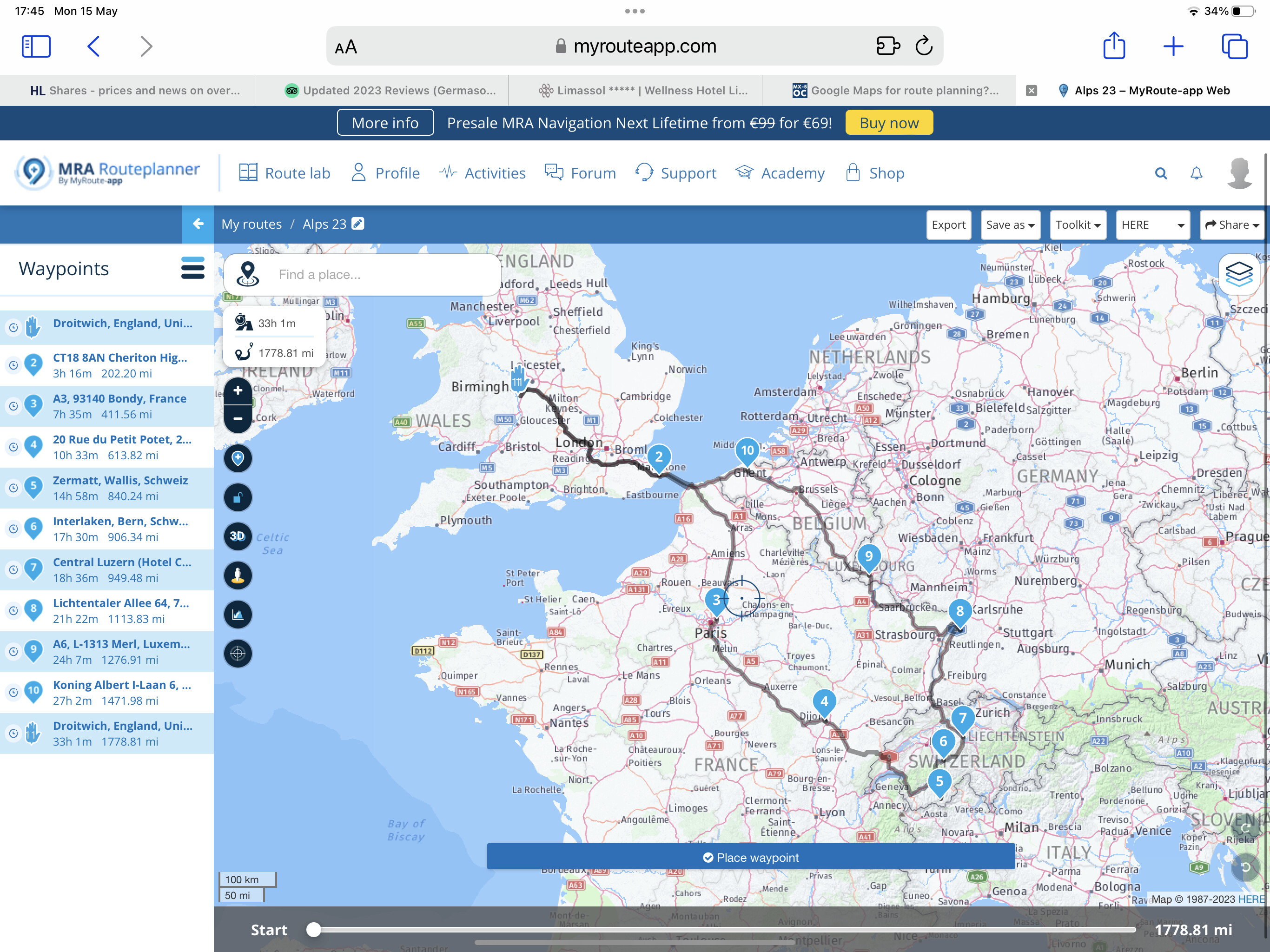
My route for this summers trip in July/Aug.
1 Like
Just stumbled across this topic via the weekly digest email, very interesting.
I too have been looking for an alternative to my trusty Garmin + Basecamp combo, which I’ve been using on the bike for 10+ years all around Europe and beyond, and I can’t believe that there’s not a fully-fledged route app available which a) deals in standard GPX tracks & routes, b) works with Apple Car Play, and c) doesn’t need a constant internet connection.
I’m heading down through France & Spain this September in the ND and will probably end up suction-cupping my Motored Navigator V to the already tiny windscreen. ![]()
1 Like
Sorry to come into this a bit late, but I’ve been away on the high seas for a few days, and with no internet connection.
Personally I would never use Google for route planning, Why>?,: well over the last 12 months I have had two deliveries made where the delivery drivers were strangers to my home. In both cases , large heavy vehicles, one a car carrier and the second delivering 15 tons of stone, and both were sent in a circuitous route, on very narrow roads, crossing a narrow and weight restricted canal swing bridge, and adding 1.5 miles to the journey. Made all the more ridiculous because I live on a busy main road.
If they are >7.5 Tonne they really should only use lorry specific sat nav. We have a similar problem where I live and if they won’t use a satnav that can filter on a weight limit then they end usually end up at a weak bridge with a 7.5T limit. Most of them then just drive over it. You can’t expect Google to know the user is driving an 8 wheel tipper.
As a car owner I have tried all sorts, Google maps is IMO the least bad for casual navigation. Tom Tom is also very good. Last time I used Garmin it was a little behind (and the unit was prone to freezing) but they might be better now.
The worst have been the inbuilt stanavs in Hondas, Mitisubishis and currently my MX-5. At least it errs on the side of caution, at the expense sometimes of vastly increased distance.
My current favourite technique is to use Google maps on the phone (Brodit mount) while displaying the map, North up, on the MZD as a common sense check. I used to set the route on both, but it confused me, being a bear of very little brain.
Sadly, my boon companion on our long trips doesn’t like navigating with an atlas and usually declines to drive.
What do you use?
In my MX5, I use a Garmin that I purchased 7 or 8 years ago, and I update it every 6 months or thereabouts. It came with a lifetime update at zero cost, and was substantially better than my previous TomTom.
My daily drive, a Skoda, has a built in system which seems to have a dislike of B roads and a strong bias towards motorways. It is also very difficult to update, requiring use of Bluetooth and telephone. As a consequence I use it only to find specific streets, once I reach my destination town/city.
1 Like
Shout out here for https://scenic.app/ (currently iOS only but Android in development).
I was looking to plan a route recently and ran into the same issues. Eventually found Scenic which allows you to import your google maps routes via their web app or save as a gpx. file and upload via the mobile app. (it also allows imports from other route planning apps).
So far so good, what about navigation? Well, the caveat here is that I haven’t properly tested it yet (recovering from a broken hand so haven’t been able to drive for 2 months ![]() ) BUT, in principle it does everything I and the OP were looking for.
) BUT, in principle it does everything I and the OP were looking for.
It will stick to your route and you can customise what happens if you deviate. You can also download country maps so it works offline (this is a paid for feature via a credit system, but you get a pretty generous number of free credits to test out premium features when you create an account - I imported a route and got offline maps for the UK and still have credits left).
I’m not sure the map UI is quite as slick as Google/Apple/Waze etc, but it seems very readable and as it’s designed for use on a bike has a very simple setup when on the move.
Here’s the route I created for anyone who wants to take a look… ScenicApp: North Wales driving loop
1 Like
If it uses google maps as its data then you can use https://mapstogpx.com/ to convert to plotted route in to a GPX file that the satnav can handle after transferring it.
This topic was automatically closed 30 days after the last reply. New replies are no longer allowed.